[av_textblock size=“ av-medium-font-size=“ av-small-font-size=“ av-mini-font-size=“ font_color=“ color=“ id=“ custom_class=“ av_uid=’av-jz77yyyf‘ admin_preview_bg=“]
Camino Frances Etappe 4:
Durch die Pyrenäen
Pamplona nach Puente la Reina
Die dritte Etappe beginnt in der Zitadelle von Pamplona und führt an der Universität von Navarra vorbei, um die Stadt über den Cizur Menor zu verlassen. Die Stadtlandschaft weicht den Getreidefeldern, durch die wir zum Alto del Perdón, einer natürlichen Barriere zwischen dem Pamploneser Becken und Valdizarbe, aufsteigen werden. Der Abstieg wird uns nach Obanos führen, wo sich unser Weg mit dem von Somport verbindet. Von hier aus verbinden sich die beiden Wege für den Rest der Pilgerfahrt nach Santiago de Compostela.
[/av_textblock]
[av_textblock size=“ av-medium-font-size=“ av-small-font-size=“ av-mini-font-size=“ font_color=“ color=“ id=“ custom_class=“ av_uid=’av-k5wz0pwx‘ admin_preview_bg=“]
Camino Frances Etappe 4:
Video von Guiroy A Santiago
[/av_textblock]
[av_video src=’https://youtu.be/WNegqR_m4kg‘ mobile_image=“ attachment=“ attachment_size=“ format=’16-9′ width=’16‘ height=’9′ conditional_play=“ id=“ custom_class=“ av_uid=’av-kb5gyba3′]
[av_textblock size=“ av-medium-font-size=“ av-small-font-size=“ av-mini-font-size=“ font_color=“ color=“ id=“ custom_class=“ av_uid=’av-kb5dfwtm‘ admin_preview_bg=“]
Camino Frances Etappe 4:
durch die Pyrenäen
Die Etappe 4 beginnt in Pamplona und führt über die Alto del Perdon bis nach Puente la Reina. Durch anklicken auf „mehr erfahren“ kannst du auch die GPX-Daten der Etappe 4 herunterladen.
[/av_textblock]
[av_textblock size=“ av-medium-font-size=“ av-small-font-size=“ av-mini-font-size=“ font_color=“ color=“ id=“ custom_class=“ av_uid=’av-kb5deyf0′ admin_preview_bg=“]
[/av_textblock]
[av_hr class=’default‘ icon_select=’yes‘ icon=’ue808′ position=’center‘ shadow=’no-shadow‘ height=’50‘ custom_border=’av-border-thin‘ custom_width=’50px‘ custom_margin_top=’30px‘ custom_margin_bottom=’30px‘ custom_border_color=“ custom_icon_color=“ av-desktop-hide=“ av-medium-hide=“ av-small-hide=“ av-mini-hide=“ id=“ custom_class=“ av_uid=’av-5edlfh‘]
[av_hr class=’default‘ icon_select=’yes‘ icon=’ue808′ position=’center‘ shadow=’no-shadow‘ height=’50‘ custom_border=’av-border-thin‘ custom_width=’50px‘ custom_margin_top=’30px‘ custom_margin_bottom=’30px‘ custom_border_color=“ custom_icon_color=“ av-desktop-hide=“ av-medium-hide=“ av-small-hide=“ av-mini-hide=“ id=“ custom_class=“ av_uid=’av-73lt9u‘]
[av_textblock size=“ av-medium-font-size=“ av-small-font-size=“ av-mini-font-size=“ font_color=“ color=“ id=“ custom_class=“ av_uid=’av-ka01ztah‘ admin_preview_bg=“]
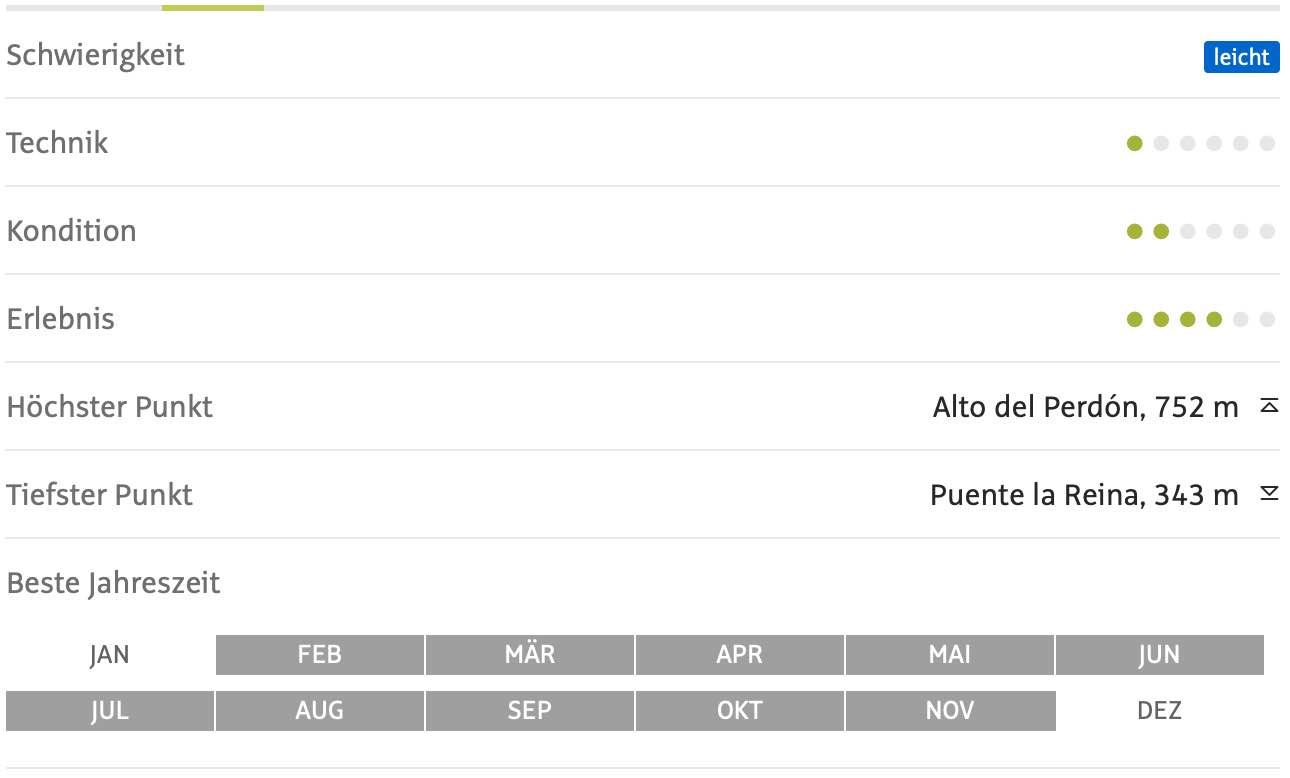
Profil Camino Frances Etappe 4
Die Einschätzung der Wegstrecke in Bezug auf Schwierigkeit, Technik, Kondition und Erlebnis. Die Höhenunterschiede werden angezeigt und eine Empfehlung für die Beste Jahreszeit diese Etappe zu laufen.
[/av_textblock]
[av_textblock size=“ av-medium-font-size=“ av-small-font-size=“ av-mini-font-size=“ font_color=“ color=“ id=“ custom_class=“ av_uid=’av-k5wyl6rr‘ admin_preview_bg=“]
[/av_textblock]
